

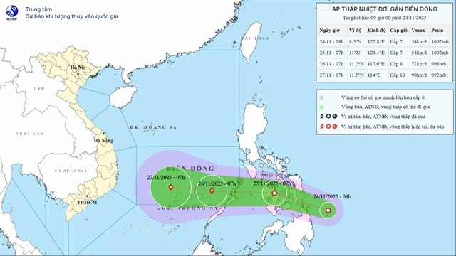
A tropical depression in the central Philippines grew into a storm Tuesday night and will enter the East Sea in the next couple hours.
The National Center for Hydro-Meteorological Forecasting reported that at 7 p.m., the storm lay over the western waters of central Philippines, with maximum winds of 74 kph and moving west-northwest at 20–25 kph.
By 7 p.m. on Wednesday, the storm would be in the eastern part of the East Sea, known internationally as the South China Sea, with maximum winds of 88 kph while maintaining its direction and speed.
By 7 p.m. on Thursday, it is expected to be in the central East Sea, with winds of 102–117 kph.
After that, the storm is projected to shift westward, slowing to about 5 kph.
By 7 p.m. on Friday, it is expected to reach the western waters of the central East Sea, with maximum winds of around 117 kph.
The Japan Meteorological Agency estimates the storm will reach maximum sustained winds of about 108 kph on Friday, Nov. 27.
The Hong Kong Observatory said the storm could reach peak winds of 120 kph and is expected to track northward as it approaches Vietnam’s south-central coast.
Mai Van Khiem, director of the National Center for Hydro-Meteorological Forecasting, said the storm could make landfall in the area from Gia Lai to Lam Dong around Nov. 30–Dec. 1, with wind speeds of around 74 kph, equivalent to a tropical depression.
He added that there is also a scenario in which the storm moves northward or dissipates at sea, with a probability of 45%. Rainfall brought by the storm is unlikely to be as extreme as the downpours recorded from Nov. 16 to 21.